
Make a donation
Gear up for your next adventure:
As an Amazon Associate, this site earns from qualifying purchases at no extra cost to you.
Selsella topographic map
Click on the map to display elevation.
Make a donation
Gear up for your next adventure:
As an Amazon Associate, this site earns from qualifying purchases at no extra cost to you.
About this map
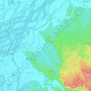
Name: Selsella topographic map, elevation, terrain.
Location: Selsella, West Garo Hills, Meghalaya, India (25.54784 89.89271 25.95781 90.15595)
Average elevation: 89 m
Minimum elevation: 17 m
Maximum elevation: 655 m
Make a donation
Gear up for your next adventure:
As an Amazon Associate, this site earns from qualifying purchases at no extra cost to you.
Other topographic maps
Click on a map to view its topography, its elevation and its terrain.
Jowai
India > Meghalaya > Thadlaskein
Jowai (IPA: ʤəʊˈwaɪ) is the headquarters of the West Jaintia Hills district of the state of Meghalaya, India, and is home to the Pnar, a sub-tribe of the Khasi people. It is located on a plateau surrounded on three sides by the Myntdu river bordering Bangladesh to the south (about 50 km from the…
Average elevation: 1,332 m