
Thank you for supporting this site ❤️
Make a donation
Make a donation
Gear up for your next adventure:
As an Amazon Associate, this site earns from qualifying purchases at no extra cost to you.
Nongpoh topographic map
Click on the map to display elevation.
Thank you for supporting this site ❤️
Make a donation
Make a donation
Gear up for your next adventure:
As an Amazon Associate, this site earns from qualifying purchases at no extra cost to you.
About this map
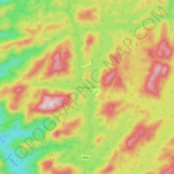
Name: Nongpoh topographic map, elevation, terrain.
Location: Nongpoh, Umling, Ri-Bhoi District, Meghalaya, India (25.85898 91.84129 25.93898 91.92129)
Average elevation: 593 m
Minimum elevation: 320 m
Maximum elevation: 873 m
Thank you for supporting this site ❤️
Make a donation
Make a donation
Gear up for your next adventure:
As an Amazon Associate, this site earns from qualifying purchases at no extra cost to you.