
Make a donation
Gear up for your next adventure:
As an Amazon Associate, this site earns from qualifying purchases at no extra cost to you.
Zlín topographic map
Click on the map to display elevation.
Make a donation
Gear up for your next adventure:
As an Amazon Associate, this site earns from qualifying purchases at no extra cost to you.
Zlín
Zlín is entirely located in the Vizovice Highlands. The highest point of the municipal territory is the top of the hill Tlustá hora with an elevation of 458 metres (1,503 ft).
Make a donation
Gear up for your next adventure:
As an Amazon Associate, this site earns from qualifying purchases at no extra cost to you.
About this map
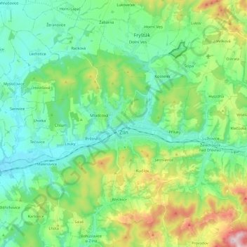
Name: Zlín topographic map, elevation, terrain.
Location: Zlín, okres Zlín, Zlínský kraj, Central Moravia, Czechia (49.16425 17.55981 49.29979 17.78662)
Average elevation: 312 m
Minimum elevation: 189 m
Maximum elevation: 653 m
Make a donation
Gear up for your next adventure:
As an Amazon Associate, this site earns from qualifying purchases at no extra cost to you.