Geolocate

Rockford topographic map

Click on the map to display elevation.

About this map

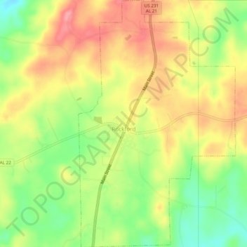
Name: Rockford topographic map, elevation, terrain.

Location: Rockford, Coosa County, Alabama, United States (32.87019 -86.22854 32.91061 -86.19788)

Average elevation: 221 m

Minimum elevation: 171 m

Maximum elevation: 263 m

Other topographic maps

Click on a map to view its topography, its elevation and its terrain.

Dollar

United States > Alabama > Coosa County

Average elevation: 122 m

Fishpond

United States > Alabama > Coosa County

Average elevation: 206 m

Hatchet

United States > Alabama > Coosa County

Average elevation: 240 m

Marble Valley

United States > Alabama > Coosa County

Average elevation: 170 m

Weogufka

United States > Alabama > Coosa County

Average elevation: 209 m

Hanover

United States > Alabama > Coosa County

Average elevation: 233 m

Hissop

United States > Alabama > Coosa County

Average elevation: 230 m

Mount Olive

United States > Alabama > Coosa County

Average elevation: 247 m

Nixburg

United States > Alabama > Coosa County

Average elevation: 213 m

Ray

United States > Alabama > Coosa County

Average elevation: 214 m

Stewartville

United States > Alabama > Coosa County

Average elevation: 217 m

Equality

United States > Alabama > Coosa County

Average elevation: 202 m

Gear up for your next adventure:

🛶Kayak Accessories - Essential gear for safe and fun kayaking adventures
🧥Ultralight Puffy Jacket - Maximum warmth that packs down to the size of an orange
🪑Insulated Seat Pad - Protect your seat from cold rocks and wet logs
💧Reusable Water Bottle - Durable water bottles for hydration on trails
🧦Merino Wool Socks - Moisture-wicking comfort for long-distance hiking

As an Amazon Associate, this site earns from qualifying purchases at no extra cost to you.