
Pishill topographic map
Interactive map
Click on the map to display elevation.
About this map
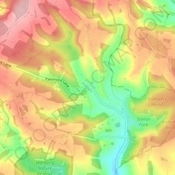
Name: Pishill topographic map, elevation, terrain.
Average elevation: 165 m
Minimum elevation: 78 m
Maximum elevation: 240 m
Other topographic maps
Click on a map to view its topography, its elevation and its terrain.
Wallingford
Royaume-Uni > Angleterre > Oxfordshire > South Oxfordshire > Crowmarsh Gifford
Wallingford, Crowmarsh Gifford, South Oxfordshire, Oxfordshire, Angleterre, Royaume-Uni
Average elevation: 51 m
Didcot
Royaume-Uni > Angleterre > Oxfordshire > South Oxfordshire > Didcot
Didcot, South Oxfordshire, Oxfordshire, South East England, Angleterre, Royaume-Uni
Average elevation: 61 m
Tetsworth
Royaume-Uni > Angleterre > Oxfordshire > South Oxfordshire
Tetsworth, South Oxfordshire, Oxfordshire, Angleterre, Royaume-Uni
Average elevation: 83 m