
Make a donation
Gear up for your next adventure:
As an Amazon Associate, this site earns from qualifying purchases at no extra cost to you.
Kolmbach topographic map
Click on the map to display elevation.
Make a donation
Gear up for your next adventure:
As an Amazon Associate, this site earns from qualifying purchases at no extra cost to you.
Kolmbach
Die Historisch-topographisch-statistische Beschreibung des Fürstenthums Lorsch, oder Kirchengeschichte des Oberrheingaues beschreibt 1812 über Kolmbach als Ort der „Zent Fürth“.
Make a donation
Gear up for your next adventure:
As an Amazon Associate, this site earns from qualifying purchases at no extra cost to you.
About this map
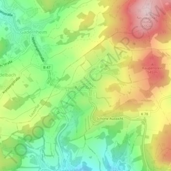
Name: Kolmbach topographic map, elevation, terrain.
Location: Kolmbach, Lindenfels, Kreis Bergstraße, Hessen, Deutschland (49.69851 8.73823 49.71677 8.77275)
Average elevation: 433 m
Minimum elevation: 292 m
Maximum elevation: 607 m
Make a donation
Gear up for your next adventure:
As an Amazon Associate, this site earns from qualifying purchases at no extra cost to you.
Other topographic maps
Click on a map to view its topography, its elevation and its terrain.
Lindenfels
Deutschland > Hessen > Kreis Bergstraße > Lindenfels > Lindenfels
Der heilklimatische Kurort Lindenfels ist im Süden Hessens unter vielen Dörfern das einzige Städtchen im Vorderen Odenwald. Die Altstadt liegt in 350 Metern Höhe auf der Sattelfläche zwischen dem bewaldeten Schenkenberg (479,6 m ü. NN) im Nordosten und einem Bergsporn mit der Burg Lindenfels (410,4 m ü.…
Average elevation: 321 m