
Gustavia topographic map
Interactive map
Click on the map to display elevation.
About this map
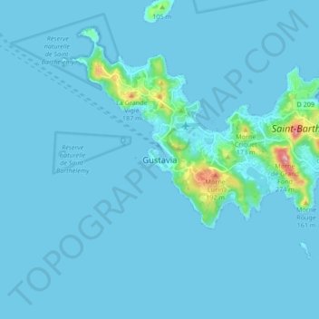
Name: Gustavia topographic map, elevation, terrain.
Location: Gustavia, Saint-Barthélemy, 97133, France (17.85570 -62.89084 17.93570 -62.81084)
Average elevation: 14 m
Minimum elevation: 0 m
Maximum elevation: 249 m
Other topographic maps
Click on a map to view its topography, its elevation and its terrain.
Île Fourchue
France > Saint-Barthélemy > Saint-Barthélemy
Île Fourchue, Saint-Barthélemy, 97133, France
Average elevation: 2 m
Île Chevreau
France > Saint-Barthélemy > Saint-Barthélemy
Île Chevreau, Saint-Barthélemy, 97133, France
Average elevation: 2 m