Geolocate

Kaylaway topographic map

Click on the map to display elevation.

About this map

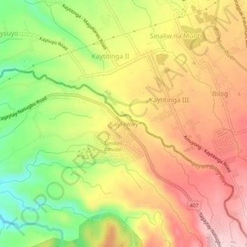
Name: Kaylaway topographic map, elevation, terrain.

Location: Kaylaway, Nasugbu, Batangas, Calabarzon, 4231, Philippines (14.07624 120.80358 14.11624 120.84358)

Average elevation: 430 m

Minimum elevation: 285 m

Maximum elevation: 550 m

Other topographic maps

Click on a map to view its topography, its elevation and its terrain.

Talamitam

Philippines > Batangas > Nasugbu > Kayrilaw

Average elevation: 328 m

Gear up for your next adventure:

🕶️Polarized Sunglasses - Protect your eyes with durable polarized lenses
🧥Waterproof Pants - Keep dry during rainy hiking conditions
🧊Insulated Water Bottle - Keeps drinks cold in summer and prevents freezing in winter
🪑Insulated Seat Pad - Protect your seat from cold rocks and wet logs
🔭Outdoor Binoculars - Lightweight binoculars for birdwatching and hiking

As an Amazon Associate, this site earns from qualifying purchases at no extra cost to you.