Geolocate

Thackery topographic map

Click on the map to display elevation.

About this map

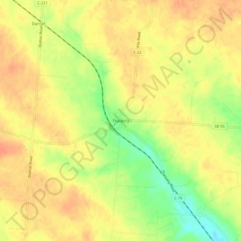
Name: Thackery topographic map, elevation, terrain.

Location: Thackery, Champaign County, Ohio, United States (40.03561 -83.93882 40.07561 -83.89882)

Average elevation: 353 m

Minimum elevation: 323 m

Maximum elevation: 368 m

Other topographic maps

Click on a map to view its topography, its elevation and its terrain.

St. Paris

United States > Ohio > Champaign County

Average elevation: 373 m

North Lewisburg

United States > Ohio > Champaign County

Average elevation: 335 m

Woodstock

United States > Ohio > Champaign County

Average elevation: 320 m

Mutual

United States > Ohio > Champaign County

Average elevation: 367 m

Mechanicsburg

United States > Ohio > Champaign County

Average elevation: 332 m

Mad River

United States > Ohio > Champaign County > West Liberty

Average elevation: 337 m

Christiansburg

United States > Ohio > Champaign County

Average elevation: 342 m

Gear up for your next adventure:

🧢Outdoor Cap - Protective cap for sun and rain during hikes
🦌Outdoor Trail Camera - Monitor wildlife activity near your favorite spots
Tent Footprint - Protect tent floor and increase durability
🧭Orienteering Kit - Tools for map reading and navigation in the wild
🗺️Topographic Maps - Detailed maps to explore trails, mountains, and wilderness areas

As an Amazon Associate, this site earns from qualifying purchases at no extra cost to you.