
Make a donation
Gear up for your next adventure:
As an Amazon Associate, this site earns from qualifying purchases at no extra cost to you.
Elsen topographic map
Click on the map to display elevation.
Make a donation
Gear up for your next adventure:
As an Amazon Associate, this site earns from qualifying purchases at no extra cost to you.
Elsen
Die katholische Pfarrkirche St. Dionysius und St. Urban liegt auf einer kleinen Anhöhe und beherrscht das Elsener Ortsbild. Der massige, fünfgeschossige, romanische Turm aus dem 11./12. Jahrhundert überragt heute wie damals alle anderen Gebäude des Ortes. Die Kirche war lange Zeit auch Mutterkirche der Gemeinden Neuhaus und Sande.
Make a donation
Gear up for your next adventure:
As an Amazon Associate, this site earns from qualifying purchases at no extra cost to you.
About this map
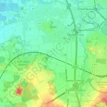
Name: Elsen topographic map, elevation, terrain.
Average elevation: 113 m
Minimum elevation: 93 m
Maximum elevation: 155 m
Make a donation
Gear up for your next adventure:
As an Amazon Associate, this site earns from qualifying purchases at no extra cost to you.
Other topographic maps
Click on a map to view its topography, its elevation and its terrain.
Barkhausen
Deutschland > Nordrhein-Westfalen > Kreis Paderborn > Paderborn > Wewer
Average elevation: 139 m
Tallesee Mittelsee
Deutschland > Nordrhein-Westfalen > Kreis Paderborn > Paderborn
Average elevation: 118 m
Make a donation
Gear up for your next adventure:
As an Amazon Associate, this site earns from qualifying purchases at no extra cost to you.
Nesthauser See
Deutschland > Nordrhein-Westfalen > Kreis Paderborn > Paderborn > Sande
Average elevation: 101 m
Habichtsee
Deutschland > Nordrhein-Westfalen > Kreis Paderborn > Paderborn > Sennelager
Average elevation: 112 m