
Make a donation
Gear up for your next adventure:
As an Amazon Associate, this site earns from qualifying purchases at no extra cost to you.
Möllbergen topographic map
Click on the map to display elevation.
Make a donation
Gear up for your next adventure:
As an Amazon Associate, this site earns from qualifying purchases at no extra cost to you.
Möllbergen
Eine im Jahr 1400 gegossene Dorfglocke dient seit ihrer Wiedererrichtung im Jahre 2001 als Wahrzeichen des Ortes. Sie befindet sich in einem zwillenförmigen Eichenstamm mit Überdach auf einer Anhöhe in der Mitte des Dorfes und wird nur am Neujahrstag um 11:00 Uhr geläutet.
Make a donation
Gear up for your next adventure:
As an Amazon Associate, this site earns from qualifying purchases at no extra cost to you.
About this map
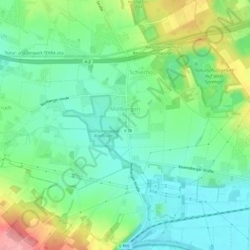
Name: Möllbergen topographic map, elevation, terrain.
Average elevation: 82 m
Minimum elevation: 46 m
Maximum elevation: 159 m
Make a donation
Gear up for your next adventure:
As an Amazon Associate, this site earns from qualifying purchases at no extra cost to you.
Other topographic maps
Click on a map to view its topography, its elevation and its terrain.
Kleinenbremen
Deutschland > Nordrhein-Westfalen > Kreis Minden-Lübbecke > Porta Westfalica
Average elevation: 131 m
Porta Westfalica
Deutschland > Nordrhein-Westfalen > Kreis Minden-Lübbecke > Porta Westfalica
Average elevation: 80 m
Barksen
Deutschland > Nordrhein-Westfalen > Kreis Minden-Lübbecke > Porta Westfalica
Average elevation: 138 m
Vennebeck
Deutschland > Nordrhein-Westfalen > Kreis Minden-Lübbecke > Porta Westfalica
Average elevation: 58 m
Make a donation
Gear up for your next adventure:
As an Amazon Associate, this site earns from qualifying purchases at no extra cost to you.
Vennebeckerbruch
Deutschland > Nordrhein-Westfalen > Kreis Minden-Lübbecke > Porta Westfalica
Average elevation: 86 m