
Make a donation
Gear up for your next adventure:
As an Amazon Associate, this site earns from qualifying purchases at no extra cost to you.
Ottensheim topographic map
Click on the map to display elevation.
Make a donation
Gear up for your next adventure:
As an Amazon Associate, this site earns from qualifying purchases at no extra cost to you.
Ottensheim
Der Ort Ottensheim liegt auf einer Höhe von 270 m ü. A. im oberen Mühlviertel an der Donau, gegenüberliegend ist das Zisterzienserstift von Wilhering. Der höchste Punkt der Gemeinde ist der Dürnberg mit einer Höhe von 549 m ü. A.
Make a donation
Gear up for your next adventure:
As an Amazon Associate, this site earns from qualifying purchases at no extra cost to you.
About this map
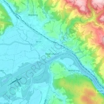
Name: Ottensheim topographic map, elevation, terrain.
Average elevation: 318 m
Minimum elevation: 250 m
Maximum elevation: 552 m
Make a donation
Gear up for your next adventure:
As an Amazon Associate, this site earns from qualifying purchases at no extra cost to you.
Other topographic maps
Click on a map to view its topography, its elevation and its terrain.
Zeurz
Österreich > Oberösterreich > Bezirk Urfahr-Umgebung > Alberndorf in der Riedmark
Average elevation: 601 m
Geitenedt
Österreich > Oberösterreich > Bezirk Urfahr-Umgebung > Kirchschlag bei Linz > Kronabittedt
Average elevation: 698 m
Make a donation
Gear up for your next adventure:
As an Amazon Associate, this site earns from qualifying purchases at no extra cost to you.
Lacken
Österreich > Oberösterreich > Bezirk Urfahr-Umgebung > Feldkirchen an der Donau > Lacken
Average elevation: 431 m
Außertreffling
Österreich > Oberösterreich > Bezirk Urfahr-Umgebung > Engerwitzdorf
Average elevation: 372 m
Sternstein
Österreich > Oberösterreich > Bezirk Urfahr-Umgebung > Vorderweißenbach
Am Osthang, rund 100 bis 150 Meter unter dem Gipfel liegt eine etwa 120 Meter breite und tiefe Mulde. Hierbei handelt es sich mit hoher Wahrscheinlichkeit um eine eiszeitliche Bildung. Weitere Vereisungsspuren wie Moränen, Eisschliffe usw. wurden bisher nicht entdeckt. Dies wäre die östlichste…
Average elevation: 936 m
Make a donation
Gear up for your next adventure:
As an Amazon Associate, this site earns from qualifying purchases at no extra cost to you.
Renning
Österreich > Oberösterreich > Bezirk Urfahr-Umgebung > Haibach im Mühlkreis
Average elevation: 711 m
Kottingersdorf
Österreich > Oberösterreich > Bezirk Urfahr-Umgebung > Alberndorf in der Riedmark
Average elevation: 610 m
Make a donation
Gear up for your next adventure:
As an Amazon Associate, this site earns from qualifying purchases at no extra cost to you.
Bad Mühllacken
Österreich > Oberösterreich > Bezirk Urfahr-Umgebung > Feldkirchen an der Donau
Average elevation: 352 m
Rohrach
Österreich > Oberösterreich > Bezirk Urfahr-Umgebung > Kirchschlag bei Linz
Average elevation: 776 m
Katzgraben
Österreich > Oberösterreich > Bezirk Urfahr-Umgebung > Altenberg bei Linz
Average elevation: 451 m
Rottenegg
Österreich > Oberösterreich > Bezirk Urfahr-Umgebung > St. Gotthard im Mühlkreis
Average elevation: 375 m
Make a donation
Gear up for your next adventure:
As an Amazon Associate, this site earns from qualifying purchases at no extra cost to you.
St. Gotthard im Mühlkreis
Österreich > Oberösterreich > Bezirk Urfahr-Umgebung > St. Gotthard im Mühlkreis > Rottenegg
Average elevation: 419 m
Make a donation
Gear up for your next adventure:
As an Amazon Associate, this site earns from qualifying purchases at no extra cost to you.
Pleschinger See
Österreich > Oberösterreich > Bezirk Urfahr-Umgebung > Steyregg > Plesching
Average elevation: 301 m
Make a donation
Gear up for your next adventure:
As an Amazon Associate, this site earns from qualifying purchases at no extra cost to you.
Schlagberg
Österreich > Oberösterreich > Bezirk Urfahr-Umgebung > Gramastetten
Average elevation: 511 m
Außertreffling
Österreich > Oberösterreich > Bezirk Urfahr-Umgebung > Engerwitzdorf
Average elevation: 372 m