Geolocate

Des Arc topographic map

Click on the map to display elevation.

About this map

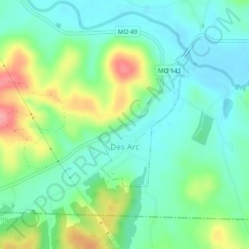
Name: Des Arc topographic map, elevation, terrain.

Location: Des Arc, Iron County, Missouri, United States (37.27823 -90.64081 37.29176 -90.62967)

Average elevation: 186 m

Minimum elevation: 154 m

Maximum elevation: 259 m

Other topographic maps

Click on a map to view its topography, its elevation and its terrain.

Belleview

United States > Missouri > Iron County

Average elevation: 328 m

Russellville

United States > Missouri > Iron County > Arcadia

Average elevation: 299 m

Gear up for your next adventure:

🧴Outdoor Sunscreen - High SPF protection for high-altitude UV exposure
🚲Heavy Duty Bike Lock - Secure your bike at the trailhead or during stops
🥾Hiking Boots - Sturdy boots providing ankle support and traction on rugged trails
🥘Camping Cookware Set - Compact nesting pots and pans for trail cooking
🎒Backpack Rain Cover - External shield to keep your entire pack dry

As an Amazon Associate, this site earns from qualifying purchases at no extra cost to you.