Geolocate

Miller Cove topographic map

Click on the map to display elevation.

About this map

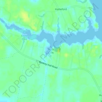
Name: Miller Cove topographic map, elevation, terrain.

Location: Miller Cove, Mathews County, Virginia, 23068, United States (37.48259 -76.34360 37.48269 -76.34350)

Average elevation: 6 m

Minimum elevation: -4 m

Maximum elevation: 15 m

Other topographic maps

Click on a map to view its topography, its elevation and its terrain.

Gear up for your next adventure:

🧴First Aid Kit - Essential first aid supplies for outdoor emergencies
🧰Emergency Multi-Tool - Compact multi-tool for outdoor survival
🔭Outdoor Binoculars - Lightweight binoculars for birdwatching and hiking
🥾Hiking Gaiters - Protect legs and shoes from mud, snow, and debris
🧥Waterproof Hiking Jacket - Protect yourself from rain and wind while hiking

As an Amazon Associate, this site earns from qualifying purchases at no extra cost to you.