Geolocate

Jordan topographic map

Click on the map to display elevation.

About this map

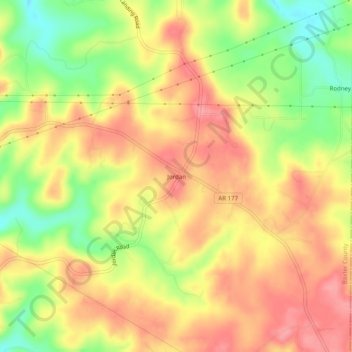
Name: Jordan topographic map, elevation, terrain.

Location: Jordan, Baxter County, Arkansas, 72519, United States (36.21285 -92.20432 36.25285 -92.16432)

Average elevation: 230 m

Minimum elevation: 176 m

Maximum elevation: 268 m

Other topographic maps

Click on a map to view its topography, its elevation and its terrain.

Gassville

United States > Arkansas > Baxter County

Average elevation: 200 m

Salesville

United States > Arkansas > Baxter County

Average elevation: 170 m

Big Flat

United States > Arkansas > Baxter County

Average elevation: 354 m

Norfork Lake

United States > Arkansas > Baxter County

Average elevation: 226 m

Briarcliff

United States > Arkansas > Baxter County

Average elevation: 236 m

Gear up for your next adventure:

🥾Trail Hiking Shoes - Durable shoes designed for rugged trails
🦯Trekking Poles - Reduced impact on joints for steep topographic climbs
🧴Sunscreen SPF - Broad-spectrum sunscreen for outdoor activities
🧶550 Survival Paracord - Versatile utility cord for emergency repairs and rigging
🕶️Polarized Sunglasses - Protect your eyes with durable polarized lenses

As an Amazon Associate, this site earns from qualifying purchases at no extra cost to you.