Geolocate

Ewing topographic map

Click on the map to display elevation.

About this map

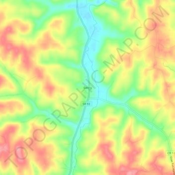
Name: Ewing topographic map, elevation, terrain.

Location: Ewing, Hocking County, Ohio, United States (39.45257 -82.45321 39.49257 -82.41321)

Average elevation: 278 m

Minimum elevation: 227 m

Maximum elevation: 322 m

Other topographic maps

Click on a map to view its topography, its elevation and its terrain.

Murray City

United States > Ohio > Hocking County

Average elevation: 257 m

Rose Lake

United States > Ohio > Hocking County

Average elevation: 295 m

Logan

United States > Ohio > Hocking County

Average elevation: 254 m

Rose Lake Dam

United States > Ohio > Hocking County

Average elevation: 297 m

Gear up for your next adventure:

🔋Lithium AA Batteries - Long-lasting power that performs in extreme cold
🌡️Emergency Mylar Blankets - Compact thermal protection for unexpected nights outdoors
🥾Waterproof Hiking Boots - Essential footwear for rugged terrain and wet Canadian trails
🚲Bike Repair Kit - Essential tools for on-trail mechanical issues
🧦Hiking Liner Socks - Thin base layer to prevent friction and blisters

As an Amazon Associate, this site earns from qualifying purchases at no extra cost to you.