Geolocate

Zuidlaren topographic map

Click on the map to display elevation.

About this map

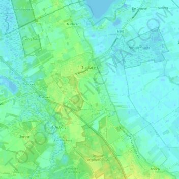
Name: Zuidlaren topographic map, elevation, terrain.

Location: Zuidlaren, Tynaarlo, Drenthe, Netherlands (53.06517 6.63964 53.10652 6.75028)

Average elevation: 5 m

Minimum elevation: -4 m

Maximum elevation: 16 m

Other topographic maps

Click on a map to view its topography, its elevation and its terrain.

Lhee

Netherlands > Drenthe

Average elevation: 11 m

Hondsrug

Netherlands > Drenthe > Exloo

Average elevation: 19 m

Zuidbarge

Netherlands > Drenthe > Emmen

Average elevation: 20 m

Gear up for your next adventure:

🔪Outdoor Multitool - Versatile tool for repairs and food prep in the wild
🔭Compact Monocular - One-handed bird watching and trail spotting
🛌Down Sleeping Bag - Superior warmth-to-weight ratio for cold nights
🪜Heavy Duty Carabiners - Multi-use clips for securing gear to your backpack
🧦Crew Hiking Socks - Comfortable socks for long-distance hikes

As an Amazon Associate, this site earns from qualifying purchases at no extra cost to you.