
Kyzyl topographic map
Click on the map to display elevation.
Kyzyl
They began to lay a new city in the village of Vilany, in Tuvan – Khem-Beldyr, which means "confluence of rivers". Technological engineer K.V. Goguntsov and topographer M. Ya. Kryuchkov arrived here in February 1914. Kryuchkov drew a general plan of the city of Belotsarsk (fund 123, opis, 2, delo 21), which basically coincides with the plan of the central part of the city of Kyzyl. The city plan shows the numbers of the land plots and gives an explanation of who owns these plots. In May 1914, the head of the Russian population in Uryankhai approved the draft rules on the allotment of land plots and the organization of a committee for the improvement of the future city. The very first plots were allocated for houses of officials, administration, for honorary Uryankhs, treasury, post and telegraph office, state fire shed.
About this map
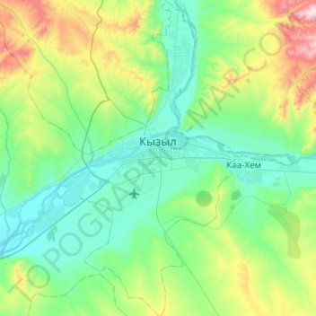
Name: Kyzyl topographic map, elevation, terrain.
Average elevation: 799 m
Minimum elevation: 600 m
Maximum elevation: 1,547 m