Geolocate

Vilaxuste topographic map

Click on the map to display elevation.

About this map

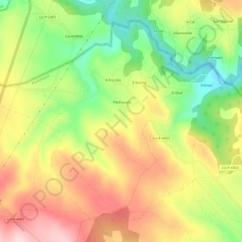
Name: Vilaxuste topographic map, elevation, terrain.

Location: Vilaxuste, Portomarín, Lugo, Galicia, España (42.83998 -7.71740 42.87528 -7.65937)

Average elevation: 511 m

Minimum elevation: 374 m

Maximum elevation: 648 m

Other topographic maps

Click on a map to view its topography, its elevation and its terrain.

Lousada

España > Galicia > Lugo > Portomarín

Average elevation: 474 m

Vendas de Narón

España > Galicia > Lugo > Portomarín

Average elevation: 659 m

O Hospital

España > Galicia > Lugo > Portomarín

Average elevation: 641 m

Toxibó

España > Galicia > Lugo > Portomarín

Average elevation: 476 m

Biduedo

España > Galicia > Lugo > Portomarín

Average elevation: 570 m

A Eirexe

España > Galicia > Lugo > Portomarín

Average elevation: 469 m

Gear up for your next adventure:

🛁Quick-Dry Microfiber Towel - Space-saving towel that dries rapidly on the move
📷Outdoor Action Camera - Capture high-elevation views and rugged adventures
🧦Outdoor Socks - Durable socks designed for hiking and outdoor sports
🧢Hiking Hat - Sun-protective and breathable hats for long treks
Camping Tent - Weather-resistant tents suitable for 2 to 6 people

As an Amazon Associate, this site earns from qualifying purchases at no extra cost to you.