Geolocate

Ameland topographic map

Click on the map to display elevation.

About this map

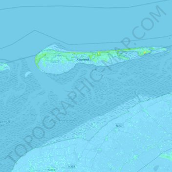
Name: Ameland topographic map, elevation, terrain.

Location: Ameland, Frisia, Netherlands (53.31874 5.55286 53.49395 6.00493)

Average elevation: 0 m

Minimum elevation: -5 m

Maximum elevation: 16 m

Other topographic maps

Click on a map to view its topography, its elevation and its terrain.

Oost-Vlieland

Netherlands > Frisia

Average elevation: 2 m

Kooiplaats

Netherlands > Frisia > Buren

Average elevation: 1 m

Loënga

Netherlands > Frisia > Loënga

Average elevation: 0 m

Vierhuizen

Netherlands > Frisia > Allingawier

Average elevation: -2 m

Leeuwarden

Netherlands > Frisia > Leeuwarden

Average elevation: 0 m

Gear up for your next adventure:

🥾Hiking Gaiters - Protect legs and shoes from mud, snow, and debris
🥾Hiking Boots - Sturdy boots providing ankle support and traction on rugged trails
🔪Outdoor Multitool - Versatile tool for repairs and food prep in the wild
🔥Camping Stove - Portable stoves to cook outdoors with ease
🧢Outdoor Visor - Breathable visor for sunny hikes

As an Amazon Associate, this site earns from qualifying purchases at no extra cost to you.