Geolocate

Tinopai topographic map

Click on the map to display elevation.

About this map

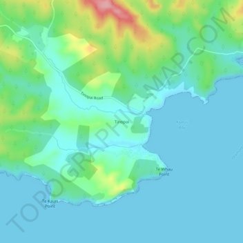
Name: Tinopai topographic map, elevation, terrain.

Location: Tinopai, Kaipara District, Northland, New Zealand (-36.26968 174.22218 -36.22968 174.26218)

Average elevation: 27 m

Minimum elevation: 0 m

Maximum elevation: 132 m

Other topographic maps

Click on a map to view its topography, its elevation and its terrain.

Wairoa River

New Zealand > Northland > Kaipara District

Average elevation: 42 m

Lake Kaiiwi

New Zealand > Northland > Kaipara District

Average elevation: 79 m

Lake Rototuna

New Zealand > Northland > Kaipara District

Average elevation: 120 m

Gear up for your next adventure:

🪑Insulated Seat Pad - Protect your seat from cold rocks and wet logs
❄️Traction Ice Cleats - Slip-on spikes for icy trails and winter hiking
🥾Approach Shoes - Shoes designed for climbing approaches and rugged trails
🪑Ultralight Camping Stool - Compact seating for rest stops during long hikes
🎒Fully Waterproof Backpack - Total protection for photography gear and electronics

As an Amazon Associate, this site earns from qualifying purchases at no extra cost to you.