
Make a donation
Gear up for your next adventure:
As an Amazon Associate, this site earns from qualifying purchases at no extra cost to you.
Klagenfurt topographic map
Click on the map to display elevation.
Make a donation
Gear up for your next adventure:
As an Amazon Associate, this site earns from qualifying purchases at no extra cost to you.
About this map
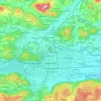
Name: Klagenfurt topographic map, elevation, terrain.
Location: Klagenfurt, Carinthia, Austria (46.57438 14.21028 46.70871 14.41626)
Average elevation: 531 m
Minimum elevation: 406 m
Maximum elevation: 1,005 m
Make a donation
Gear up for your next adventure:
As an Amazon Associate, this site earns from qualifying purchases at no extra cost to you.
Other topographic maps
Click on a map to view its topography, its elevation and its terrain.
Klagenfurt Land
Austria > Carinthia > Bezirk Klagenfurt-Land > Krumpendorf am Wörthersee
Average elevation: 894 m
Bad Eisenkappel/Železna Kapla
Austria > Carinthia > Bezirk Völkermarkt > Eisenkappel-Vellach
Average elevation: 914 m
Make a donation
Gear up for your next adventure:
As an Amazon Associate, this site earns from qualifying purchases at no extra cost to you.