Geolocate

Crossen topographic map

Click on the map to display elevation.

Crossen

In Erlau befindet sich seit 2012 eine Windkraftanlage Enercon E-101 mit 135 m Nabenhöhe. Sie ist die höchste Windkraftanlage in Sachsen.

About this map

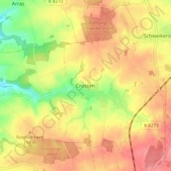
Name: Crossen topographic map, elevation, terrain.

Location: Crossen, Erlau, Mittelsachsen, Sachsen, 09326, Deutschland (51.01485 12.90275 51.05485 12.94275)

Average elevation: 284 m

Minimum elevation: 238 m

Maximum elevation: 315 m

Gear up for your next adventure:

📷Outdoor Action Camera - Capture high-elevation views and rugged adventures
🔥Emergency Fire Starter - Reliable ignition source for all weather conditions
🥾Trail Hiking Boots - Supportive boots for rough trails
🛶Waterproof Dry Bags - Keep electronics and clothes dry during river crossings
🔦LED Headlamp - Hands-free lighting for early morning starts or late finishes

As an Amazon Associate, this site earns from qualifying purchases at no extra cost to you.