
Make a donation
Gear up for your next adventure:
As an Amazon Associate, this site earns from qualifying purchases at no extra cost to you.
Goshen topographic map
Click on the map to display elevation.
Make a donation
Gear up for your next adventure:
As an Amazon Associate, this site earns from qualifying purchases at no extra cost to you.
Goshen
The long ridge of Mount Sunapee occupies the eastern edge of town. The highest point in Goshen is an unnamed knob on the ridge (near Goves Mountain) where the elevation reaches 2,529 feet (771 m) above sea level.
Make a donation
Gear up for your next adventure:
As an Amazon Associate, this site earns from qualifying purchases at no extra cost to you.
About this map
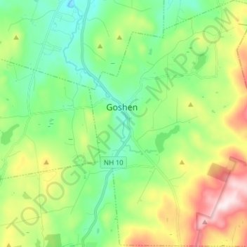
Name: Goshen topographic map, elevation, terrain.
Location: Goshen, Sullivan County, New Hampshire, 03752, United States (43.24914 -72.16550 43.34080 -72.06332)
Average elevation: 417 m
Minimum elevation: 249 m
Maximum elevation: 765 m
Make a donation
Gear up for your next adventure:
As an Amazon Associate, this site earns from qualifying purchases at no extra cost to you.
Other topographic maps
Click on a map to view its topography, its elevation and its terrain.
Kolelemook Lake
United States > New Hampshire > Sullivan County > Springfield
Average elevation: 463 m
North Charlestown
United States > New Hampshire > Sullivan County > Charlestown
Average elevation: 162 m
South Charlestown
United States > New Hampshire > Sullivan County > Charlestown
Average elevation: 153 m
Make a donation
Gear up for your next adventure:
As an Amazon Associate, this site earns from qualifying purchases at no extra cost to you.
Make a donation
Gear up for your next adventure:
As an Amazon Associate, this site earns from qualifying purchases at no extra cost to you.