Geolocate

Leoma topographic map

Click on the map to display elevation.

About this map

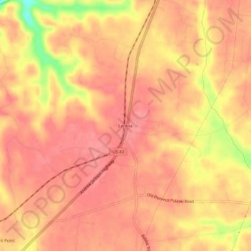
Name: Leoma topographic map, elevation, terrain.

Location: Leoma, Lawrence County, Tennessee, 38468, United States (35.14147 -87.36807 35.18147 -87.32807)

Average elevation: 277 m

Minimum elevation: 210 m

Maximum elevation: 299 m

Gear up for your next adventure:

🧴Waterproofing Spray - Restore the DWR coating on jackets and tents
💧Filtered Water Bottle - Safe drinking water on the go
🥾Lightweight Hiking Boots - Boots for comfort and mobility on long hikes
🧭GPS Tracker - Track your location in remote areas safely
🛶Waterproof Dry Bags - Keep electronics and clothes dry during river crossings

As an Amazon Associate, this site earns from qualifying purchases at no extra cost to you.