
Waynesville topographic map
Click on the map to display elevation.
Waynesville
Most of the town of Waynesville lies between 2,600 and 3,000 feet (790 and 910 m) above sea level, in a valley among 5,000-to-6,410-foot (1,520 to 1,950 m) mountain peaks. With the high Great Balsam Mountains to the west-southwest, and the Plott Balsams to the west-northwest, a handful of peaks over 6000' in elevation are clearly visible from town. A USGS survey marker at the old Haywood County Courthouse in downtown Waynesville lists the elevation as 2,752 feet (839 m) above sea level.
About this map
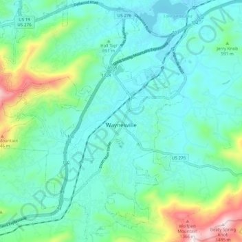
Name: Waynesville topographic map, elevation, terrain.
Average elevation: 921 m
Minimum elevation: 772 m
Maximum elevation: 1,484 m
Other topographic maps
Click on a map to view its topography, its elevation and its terrain.
Cataloochee Valley Viewpoint
United States > North Carolina > Haywood County > Cataloochee
Average elevation: 1,058 m
Panther Creek
United States > North Carolina > Haywood County > Panther Creek
Average elevation: 873 m