
Make a donation
Gear up for your next adventure:
As an Amazon Associate, this site earns from qualifying purchases at no extra cost to you.
Taillet topographic map
Click on the map to display elevation.
Make a donation
Gear up for your next adventure:
As an Amazon Associate, this site earns from qualifying purchases at no extra cost to you.
Taillet
La superficie de la commune est de 1 002 hectares. L'altitude varie entre 198 mètres (dans la vallée de la Palmera, au coin sud-est de la commune) et 681 mètres (à la limite nord de la commune, à une courte distance au nord-ouest du village).
Make a donation
Gear up for your next adventure:
As an Amazon Associate, this site earns from qualifying purchases at no extra cost to you.
About this map
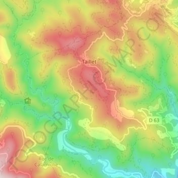
Name: Taillet topographic map, elevation, terrain.
Average elevation: 446 m
Minimum elevation: 179 m
Maximum elevation: 754 m
Make a donation
Gear up for your next adventure:
As an Amazon Associate, this site earns from qualifying purchases at no extra cost to you.