Geolocate

Kuningan topographic map

Click on the map to display elevation.

About this map

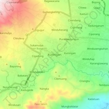
Name: Kuningan topographic map, elevation, terrain.

Location: Kuningan, West Java, Java, 45511, Indonesia (-7.02215 108.43680 -6.94215 108.51680)

Average elevation: 562 m

Minimum elevation: 186 m

Maximum elevation: 1,114 m

Other topographic maps

Click on a map to view its topography, its elevation and its terrain.

Gear up for your next adventure:

🔦UV Flashlight - Detect minerals or specific insects in the dark
🥾Waterproof Trail Shoes - Shoes designed to handle wet terrain
Lightweight Backpacking Tent - Compact tent for efficient hiking trips
🥾Mountain Hiking Boots - High-traction boots for rocky terrain
🪑Ultralight Camping Stool - Compact seating for rest stops during long hikes

As an Amazon Associate, this site earns from qualifying purchases at no extra cost to you.