
Make a donation
Gear up for your next adventure:
As an Amazon Associate, this site earns from qualifying purchases at no extra cost to you.
Mount Penanggungan topographic map
Click on the map to display elevation.
Make a donation
Gear up for your next adventure:
As an Amazon Associate, this site earns from qualifying purchases at no extra cost to you.
Mount Penanggungan
There are sub-peaks around Penanggungan, starting to the southeast from Mount Wangi (Gunung Wangi) at 970 meters above sea level, Mount Bekel Jolotundo elevated 1,200 meters ASL, a semi-freestanding peak to the northwest; Puncak Kemuncup rising to 1,200 meters on the eastern face, Puncak Sarah Klopo on the southwestern slope elevated 1,250 meters, Puncak Awang-Awang located about 1,275 meters up the southwestern side, and Puncak Garuda Penanggungan south of the main peak topographing 1,520 meters. Bayangan Hill, located on the southern face at 1,250 meters up, is the main tourist attraction and a scenic spot. The peak is in Mojokerto Regency, with a portion of the slope in Prigen, Pasuruan Regency. As of 3 October 2024, Mt. Penanggungan has 1,213 Google Maps reviews with the quotient of stars to reviews noted to be 4.8.
Make a donation
Gear up for your next adventure:
As an Amazon Associate, this site earns from qualifying purchases at no extra cost to you.
About this map
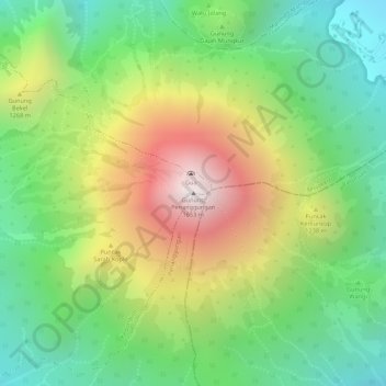
Name: Mount Penanggungan topographic map, elevation, terrain.
Average elevation: 1,061 m
Minimum elevation: 636 m
Maximum elevation: 1,639 m
Make a donation
Gear up for your next adventure:
As an Amazon Associate, this site earns from qualifying purchases at no extra cost to you.