Geolocate

Sylacauga topographic map

Click on the map to display elevation.

About this map

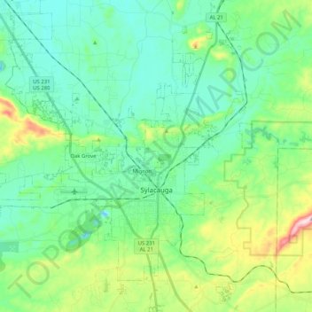
Name: Sylacauga topographic map, elevation, terrain.

Location: Sylacauga, Talladega County, Alabama, United States (33.10623 -86.35769 33.27631 -86.18937)

Average elevation: 194 m

Minimum elevation: 109 m

Maximum elevation: 458 m

Other topographic maps

Click on a map to view its topography, its elevation and its terrain.

Dry Valley

United States > Alabama > Talladega County > Lincoln

Average elevation: 173 m

Bethlehem

United States > Alabama > Talladega County

Average elevation: 187 m

Walco

United States > Alabama > Talladega County > Sylacauga

Average elevation: 173 m

Munford

United States > Alabama > Talladega County > Munford

Average elevation: 191 m

Saint Ives

United States > Alabama > Talladega County

Average elevation: 157 m

The Moon

United States > Alabama > Talladega County > Sylacauga

Average elevation: 199 m

Gear up for your next adventure:

🥾Hiking Shoes - Durable and comfortable shoes for trail hiking
🎒Fully Waterproof Backpack - Total protection for photography gear and electronics
❄️Traction Ice Cleats - Slip-on spikes for icy trails and winter hiking
🔦LED Flashlight - Powerful and long-lasting flashlight for camping and emergencies
🧳Compression Sacks - Maximize space in your backpack by shrinking gear

As an Amazon Associate, this site earns from qualifying purchases at no extra cost to you.