Geolocate

Villanueva topographic map

Click on the map to display elevation.

About this map

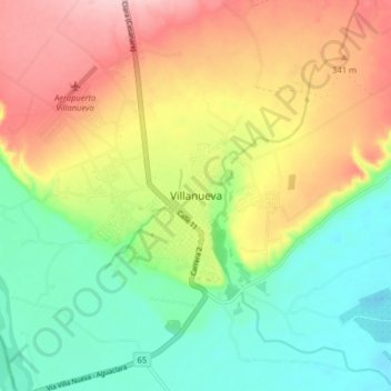
Name: Villanueva topographic map, elevation, terrain.

Location: Villanueva, Casanare, Colombia (4.57487 -72.96524 4.65487 -72.88524)

Average elevation: 283 m

Minimum elevation: 202 m

Maximum elevation: 390 m

Gear up for your next adventure:

🧴Waterproofing Spray - Restore the DWR coating on jackets and tents
🗺️Topographic Maps - Detailed maps to explore trails, mountains, and wilderness areas
🧦Merino Wool Socks - Moisture-wicking comfort for long-distance hiking
🧥Thermal Layer - Insulating layer for cold outdoor conditions
🛌Down Sleeping Bag - Superior warmth-to-weight ratio for cold nights

As an Amazon Associate, this site earns from qualifying purchases at no extra cost to you.