
Lac Payne topographic map
Interactive map
Click on the map to display elevation.
About this map
Name: Lac Payne topographic map, elevation, terrain.
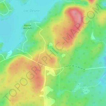
Average elevation: 337 m
Minimum elevation: 295 m
Maximum elevation: 397 m
Other topographic maps
Click on a map to view its topography, its elevation and its terrain.
Lac-Désert
Canada > Quebec > La Minerve
Lac-Désert, La Minerve, Les Laurentides, Laurentides, Quebec, J0T 1S0, Canada
Average elevation: 334 m