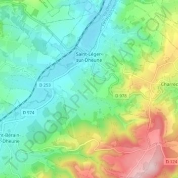
Saint-Léger-sur-Dheune topographic map
Interactive map
Click on the map to display elevation.
About this map
Name: Saint-Léger-sur-Dheune topographic map, elevation, terrain.
Average elevation: 309 m
Minimum elevation: 227 m
Maximum elevation: 489 m

Click on the map to display elevation.
Name: Saint-Léger-sur-Dheune topographic map, elevation, terrain.
Average elevation: 309 m
Minimum elevation: 227 m
Maximum elevation: 489 m