Geolocate

San Raffaele Cimena topographic map

Click on the map to display elevation.

About this map

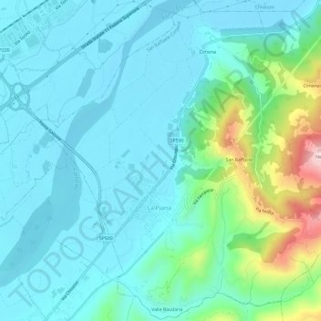
Name: San Raffaele Cimena topographic map, elevation, terrain.

Location: San Raffaele Cimena, Torino, Piemont, Italy (45.13275 7.82593 45.17374 7.88480)

Average elevation: 246 m

Minimum elevation: 180 m

Maximum elevation: 536 m

Gear up for your next adventure:

🥾Hiking Shorts - Breathable shorts suitable for summer hikes
🧴Waterproofing Spray - Restore the DWR coating on jackets and tents
🧦Hiking Liner Socks - Thin base layer to prevent friction and blisters
🥾Waterproof Trail Shoes - Shoes designed to handle wet terrain
Tent Footprint - Protect tent floor and increase durability

As an Amazon Associate, this site earns from qualifying purchases at no extra cost to you.