
Make a donation
Gear up for your next adventure:
As an Amazon Associate, this site earns from qualifying purchases at no extra cost to you.
Sobrado topographic map
Click on the map to display elevation.
Make a donation
Gear up for your next adventure:
As an Amazon Associate, this site earns from qualifying purchases at no extra cost to you.
Sobrado
Estes sistemas de montanha estão a cerca de 750 m de altitude. Neles se encontra o Monte Campelo, com 806 m, e a montanha do Pilar, com 801 m, situada na fronteira da província.
Make a donation
Gear up for your next adventure:
As an Amazon Associate, this site earns from qualifying purchases at no extra cost to you.
About this map
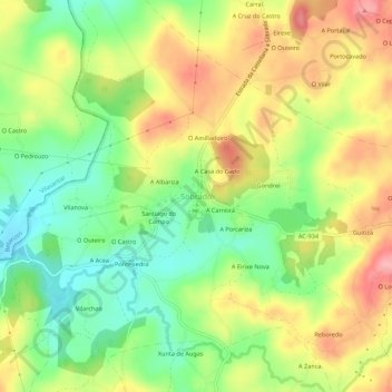
Name: Sobrado topographic map, elevation, terrain.
Location: Sobrado, Terra de Melide, Corunha, Galiza, 15813, Espanha (43.02050 -8.04238 43.06050 -8.00238)
Average elevation: 526 m
Minimum elevation: 469 m
Maximum elevation: 591 m
Make a donation
Gear up for your next adventure:
As an Amazon Associate, this site earns from qualifying purchases at no extra cost to you.
Other topographic maps
Click on a map to view its topography, its elevation and its terrain.