
Make a donation
Gear up for your next adventure:
As an Amazon Associate, this site earns from qualifying purchases at no extra cost to you.
Rehefeld-Zaunhaus topographic map
Click on the map to display elevation.
Make a donation
Gear up for your next adventure:
As an Amazon Associate, this site earns from qualifying purchases at no extra cost to you.
Rehefeld-Zaunhaus
Die Höhe des Ortes beträgt 650–845 m über NN, er gilt als einer der schneesichersten des Osterzgebirges. Seine Fluren befinden sich im Quellgebiet der Wilden Weißeritz. Bis 1972 bestand noch der Haltepunkt Hermsdorf-Rehefeld der Eisenbahnstrecke Nossen–Moldava. Hier sollte die schmalspurige Pöbeltalbahn abzweigen.
Make a donation
Gear up for your next adventure:
As an Amazon Associate, this site earns from qualifying purchases at no extra cost to you.
About this map
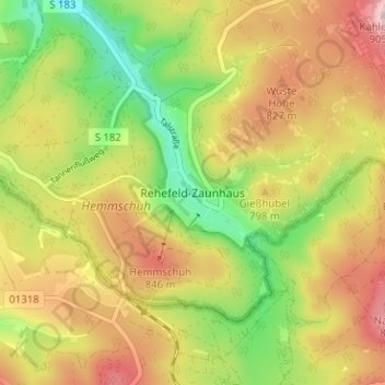
Name: Rehefeld-Zaunhaus topographic map, elevation, terrain.
Average elevation: 772 m
Minimum elevation: 643 m
Maximum elevation: 901 m
Make a donation
Gear up for your next adventure:
As an Amazon Associate, this site earns from qualifying purchases at no extra cost to you.