Geolocate

Petoskey topographic map

Click on the map to display elevation.

About this map

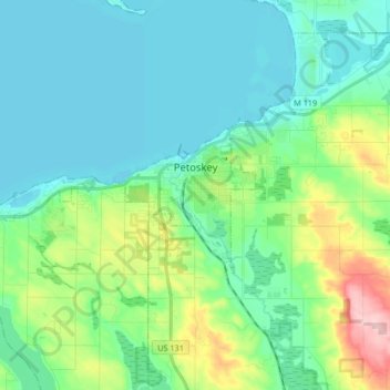
Name: Petoskey topographic map, elevation, terrain.

Location: Petoskey, Emmet County, Michigan, United States (45.34486 -85.09597 45.38477 -84.92994)

Average elevation: 223 m

Minimum elevation: 174 m

Maximum elevation: 395 m

Other topographic maps

Click on a map to view its topography, its elevation and its terrain.

Cross Village

United States > Michigan > Emmet County

Average elevation: 201 m

Epsilon

United States > Michigan > Emmet County > Epsilon

Average elevation: 230 m

Gear up for your next adventure:

🚲Heavy Duty Bike Lock - Secure your bike at the trailhead or during stops
🧣Evaporative Cooling Towel - Beat the heat during intense summer climbs
🧢Sun Hat - Wide-brim hat for sun protection
💡LED Camping Lantern - Illuminate your campsite with long-lasting lanterns
🧤Thermal Hiking Gloves - Grip-enhanced gloves for cold-weather altitude trekking

As an Amazon Associate, this site earns from qualifying purchases at no extra cost to you.