Geolocate

Cholet topographic map

Click on the map to display elevation.

Cholet

La superficie de la commune est de 8 747 hectares ; son altitude varie entre 63 et 184 mètres.

About this map

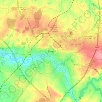
Name: Cholet topographic map, elevation, terrain.

Location: Cholet, Maine-et-Loire, Pays de la Loire, France métropolitaine, 49300, France (47.02173 -0.92013 47.10173 -0.84013)

Average elevation: 111 m

Minimum elevation: 62 m

Maximum elevation: 158 m

Gear up for your next adventure:

❄️Traction Ice Cleats - Slip-on spikes for icy trails and winter hiking
🧴Sunscreen SPF - Broad-spectrum sunscreen for outdoor activities
🧤Rechargeable Heated Gloves - Extreme warmth for Canadian winter expeditions
🧥Waterproof Jacket - Lightweight rain jackets for hiking and outdoor activities
🏃Hydration Running Vest - Carry water and maps close to your body for speed

As an Amazon Associate, this site earns from qualifying purchases at no extra cost to you.