
Make a donation
Gear up for your next adventure:
As an Amazon Associate, this site earns from qualifying purchases at no extra cost to you.
Bad Liebenzell topographic map
Click on the map to display elevation.
Make a donation
Gear up for your next adventure:
As an Amazon Associate, this site earns from qualifying purchases at no extra cost to you.
Bad Liebenzell
Das zentrale Bad Liebenzell liegt westlich der Landesmitte von Baden-Württemberg im Nagoldtal. Das Stadtgebiet hat eine Höhenlage von 310 (Monbachtal) bis 687 Metern (Gemarkung Maisenbach-Zainen), erstreckt sich ungefähr 5,5 km entlang der Süd-Nord-Achse des Nagoldtales und quer dazu über die Schwarzwaldhöhen hinweg etwa 13 km weit. Es liegt zur Gänze im Naturpark Schwarzwald Mitte/Nord.
Make a donation
Gear up for your next adventure:
As an Amazon Associate, this site earns from qualifying purchases at no extra cost to you.
About this map
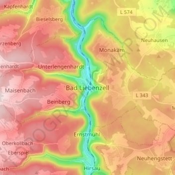
Name: Bad Liebenzell topographic map, elevation, terrain.
Average elevation: 529 m
Minimum elevation: 304 m
Maximum elevation: 688 m
Make a donation
Gear up for your next adventure:
As an Amazon Associate, this site earns from qualifying purchases at no extra cost to you.