
Make a donation
Gear up for your next adventure:
As an Amazon Associate, this site earns from qualifying purchases at no extra cost to you.
Tiputini topographic map
Click on the map to display elevation.
Make a donation
Gear up for your next adventure:
As an Amazon Associate, this site earns from qualifying purchases at no extra cost to you.
Tiputini
La parroquia tiene un clima ecuatorial, comprendido entre altitudes de 205 – 215 m s. n. m., con temperatura promedio anual entre 23.0 °C y 25.5°
Make a donation
Gear up for your next adventure:
As an Amazon Associate, this site earns from qualifying purchases at no extra cost to you.
About this map
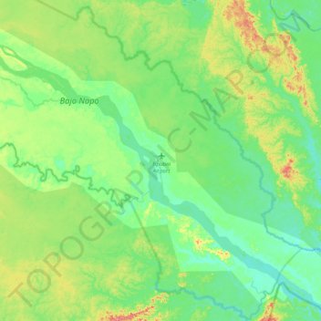
Name: Tiputini topographic map, elevation, terrain.
Location: Tiputini, Aguarico, Orellana, Ecuador (-0.90428 -75.89375 -0.66014 -75.50192)
Average elevation: 193 m
Minimum elevation: 169 m
Maximum elevation: 257 m
Make a donation
Gear up for your next adventure:
As an Amazon Associate, this site earns from qualifying purchases at no extra cost to you.
Other topographic maps
Click on a map to view its topography, its elevation and its terrain.