Geolocate

Ayesa topographic map

Click on the map to display elevation.

About this map

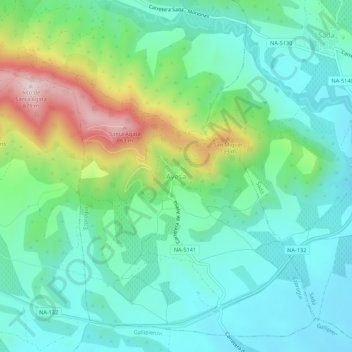
Name: Ayesa topographic map, elevation, terrain.

Location: Ayesa, Navarra, España (42.55110 -1.44148 42.59110 -1.40148)

Average elevation: 539 m

Minimum elevation: 420 m

Maximum elevation: 865 m

Gear up for your next adventure:

🧰Survival Kit - Essential gear for emergencies in the wilderness
🧥Insulated Jacket - Keep warm in cold outdoor conditions
🥾Lightweight Hiking Shoes - Comfortable shoes for day hikes
🥾Lightweight Hiking Boots - Boots for comfort and mobility on long hikes
🔭Outdoor Binoculars - Lightweight binoculars for birdwatching and hiking

As an Amazon Associate, this site earns from qualifying purchases at no extra cost to you.