Geolocate

Manywanda topographic map

Click on the map to display elevation.

About this map

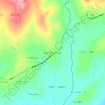
Name: Manywanda topographic map, elevation, terrain.

Location: Manywanda, West Seme ward, Seme, Kisumu County, Kenya (-0.16145 34.44944 -0.12145 34.48944)

Average elevation: 1,187 m

Minimum elevation: 1,138 m

Maximum elevation: 1,277 m

Gear up for your next adventure:

🥾Trail Running Shoes - Lightweight and durable shoes for trail running
🕶️Polarized Sunglasses - Reduces glare from snow and water at high elevations
🚲Heavy Duty Bike Lock - Secure your bike at the trailhead or during stops
🧥Thermal Layer - Insulating layer for cold outdoor conditions
🧥Fleece Jacket - Warm and lightweight jacket for layering

As an Amazon Associate, this site earns from qualifying purchases at no extra cost to you.