
Make a donation
Gear up for your next adventure:
As an Amazon Associate, this site earns from qualifying purchases at no extra cost to you.
Rabenäußig topographic map
Click on the map to display elevation.
Make a donation
Gear up for your next adventure:
As an Amazon Associate, this site earns from qualifying purchases at no extra cost to you.
Rabenäußig
Rabenäußig liegt oberhalb des Tales der Effelder in etwa 580 Metern Höhe am Südrand des Thüringer Schiefergebirges in der Nähe der B89 und besteht aus den Orten Hohetann, Rabenäußig, Fichtach sowie Melchersberg. Der Siedlungskern befindet sich um Melchersberg und Fichtach, wo mit Feuerwehrhaus, Gaststätte und Friedhofskapelle wichtige örtliche Einrichtungen vorhanden sind.
Make a donation
Gear up for your next adventure:
As an Amazon Associate, this site earns from qualifying purchases at no extra cost to you.
About this map
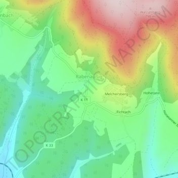
Name: Rabenäußig topographic map, elevation, terrain.
Average elevation: 556 m
Minimum elevation: 400 m
Maximum elevation: 808 m
Make a donation
Gear up for your next adventure:
As an Amazon Associate, this site earns from qualifying purchases at no extra cost to you.
Other topographic maps
Click on a map to view its topography, its elevation and its terrain.
Mengersgereuth-Hämmern
Deutschland > Thüringen > Landkreis Sonneberg > Frankenblick
Average elevation: 548 m