Geolocate

Hawālbāgh topographic map

Click on the map to display elevation.

About this map

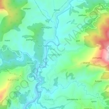
Name: Hawālbāgh topographic map, elevation, terrain.

Location: Hawālbāgh, Almora, Uttarakhand, 263601, India (29.62386 79.61303 29.66386 79.65303)

Average elevation: 1,283 m

Minimum elevation: 1,130 m

Maximum elevation: 1,730 m

Gear up for your next adventure:

🧴Outdoor Sunscreen - High SPF protection for high-altitude UV exposure
🐕Hiking Dog Pack - Let your canine companion carry their own water and food
🔭Outdoor Binoculars - Lightweight binoculars for birdwatching and hiking
🧢Hiking Sun Hat - Wide-brimmed protection for exposed mountain ridges
🥾Hiking Shoes - Durable and comfortable shoes for trail hiking

As an Amazon Associate, this site earns from qualifying purchases at no extra cost to you.