

Fairview topographic map
Click on the map to display elevation.
Fairview
Fairview was incorporated on July 28, 1959, under the Uniform City Manager-Commission Charter as set out in the Tennessee Code Annotated. Fairview city limits are located about one mile (1.6 km) southwest from the Nashville-Davidson County line and has two interstates passing through it (I-40 & I-840). With an average elevation of 800 feet (240 m) above sea level, Fairview is about 150 feet (46 m) higher than Nashville and surrounding suburbs, which gives Fairview the advantage of being less flood prone.
About this map
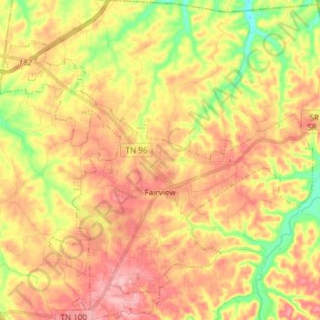
Name: Fairview topographic map, elevation, terrain.
Average elevation: 233 m
Minimum elevation: 164 m
Maximum elevation: 287 m
Other topographic maps
Click on a map to view its topography, its elevation and its terrain.



Belle Rive Highlands
United States > Tennessee > Williamson County > Brentwood
Average elevation: 224 m
Murray Lane Estates
United States > Tennessee > Williamson County > Brentwood
Average elevation: 240 m


Country Club Estates
United States > Tennessee > Williamson County > Brentwood
Average elevation: 217 m


Carrington Hills Pond
United States > Tennessee > Williamson County > Franklin
Average elevation: 224 m