Geolocate

Würzburg topographic map

Click on the map to display elevation.

About this map

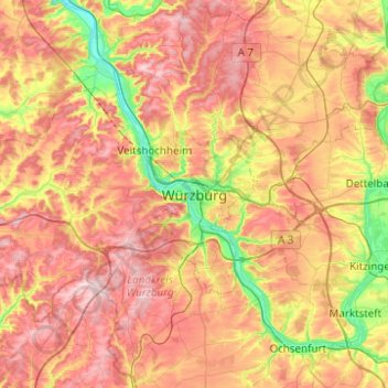
Name: Würzburg topographic map, elevation, terrain.

Location: Würzburg, Bavaria, 97070, Germany (49.63337 9.77098 49.95337 10.09098)

Average elevation: 282 m

Minimum elevation: 160 m

Maximum elevation: 395 m

Other topographic maps

Click on a map to view its topography, its elevation and its terrain.

Frauenland

Germany > Bavaria > Würzburg

Average elevation: 219 m

97078

Germany > Bavaria > Würzburg

Average elevation: 257 m

Gear up for your next adventure:

🛁Quick-Dry Microfiber Towel - Space-saving towel that dries rapidly on the move
🧣Evaporative Cooling Towel - Beat the heat during intense summer climbs
🔦LED Headlamp - Hands-free lighting for early morning starts or late finishes
📷Outdoor Action Camera - Capture high-elevation views and rugged adventures
🏕️Camping Hammock - Integrated protection for sleeping between trees

As an Amazon Associate, this site earns from qualifying purchases at no extra cost to you.