
Make a donation
Gear up for your next adventure:
As an Amazon Associate, this site earns from qualifying purchases at no extra cost to you.
Salvador Benedicto topographic map
Click on the map to display elevation.
Make a donation
Gear up for your next adventure:
As an Amazon Associate, this site earns from qualifying purchases at no extra cost to you.
Salvador Benedicto
Although a small town, the town of Don Salvador Benedicto has seen a rise in its municipal economy thanks to tourism and local agriculture. Due to its high altitude like Baguio, the town can support crops that grow in temperate areas, making it ideal for a multitude of farming businesses. Tourism is on the rise for the town especially when travellers head out into the heart of the province. Also located in the municipality are the Choco Hills, similar to Bohol's Chocolate Hills, with shared boundary of Barangay Prosperidad, San Carlos City.
Make a donation
Gear up for your next adventure:
As an Amazon Associate, this site earns from qualifying purchases at no extra cost to you.
About this map
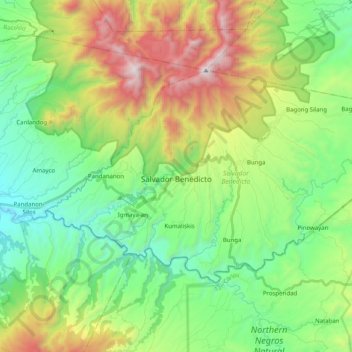
Name: Salvador Benedicto topographic map, elevation, terrain.
Average elevation: 708 m
Minimum elevation: 141 m
Maximum elevation: 1,853 m
Make a donation
Gear up for your next adventure:
As an Amazon Associate, this site earns from qualifying purchases at no extra cost to you.
Other topographic maps
Click on a map to view its topography, its elevation and its terrain.
Make a donation
Gear up for your next adventure:
As an Amazon Associate, this site earns from qualifying purchases at no extra cost to you.
Make a donation
Gear up for your next adventure:
As an Amazon Associate, this site earns from qualifying purchases at no extra cost to you.
Make a donation
Gear up for your next adventure:
As an Amazon Associate, this site earns from qualifying purchases at no extra cost to you.
Salvador Benedicto
Philippines > Negros Occidental > Salvador Benedicto > Salvador Benedicto
Average elevation: 686 m
Make a donation
Gear up for your next adventure:
As an Amazon Associate, this site earns from qualifying purchases at no extra cost to you.