
Make a donation
Gear up for your next adventure:
As an Amazon Associate, this site earns from qualifying purchases at no extra cost to you.
Stripsenjoch topographic map
Click on the map to display elevation.
Make a donation
Gear up for your next adventure:
As an Amazon Associate, this site earns from qualifying purchases at no extra cost to you.
Stripsenjoch
Das Stripsenjoch ist ein Pass (= Joch) in Tirol/Österreich mit einer Höhe von 1577 m ü. A., der den Übergang vom Zahmen Kaiser zum Wilden Kaiser bildet. Darüber hinaus markiert es die Wasserscheide zwischen dem Kaiserbach im Kaisertal im Westen (Richtung Kufstein) und dem Kaiserbachtal im Osten (Richtung Kirchdorf i.T.).
Make a donation
Gear up for your next adventure:
As an Amazon Associate, this site earns from qualifying purchases at no extra cost to you.
About this map
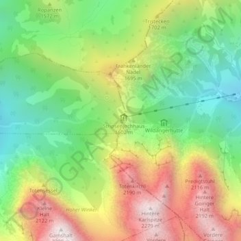
Name: Stripsenjoch topographic map, elevation, terrain.
Average elevation: 1,529 m
Minimum elevation: 989 m
Maximum elevation: 2,250 m
Make a donation
Gear up for your next adventure:
As an Amazon Associate, this site earns from qualifying purchases at no extra cost to you.