
Make a donation
Gear up for your next adventure:
As an Amazon Associate, this site earns from qualifying purchases at no extra cost to you.
Piz Vadret topographic map
Click on the map to display elevation.
Make a donation
Gear up for your next adventure:
As an Amazon Associate, this site earns from qualifying purchases at no extra cost to you.
Piz Vadret
Piz Vadret is a mountain of the Albula Alps, in Graubünden. With an altitude of 3,229 metres above sea level, Piz Vadret is the highest mountain of the Albula Alps north of Piz Kesch. At the base of the north face lies a glacier named Vadret da Grialetsch. The closest locality is Brail, in the Engadin.
Make a donation
Gear up for your next adventure:
As an Amazon Associate, this site earns from qualifying purchases at no extra cost to you.
About this map
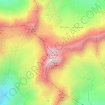
Name: Piz Vadret topographic map, elevation, terrain.
Average elevation: 2,824 m
Minimum elevation: 2,426 m
Maximum elevation: 3,190 m
Make a donation
Gear up for your next adventure:
As an Amazon Associate, this site earns from qualifying purchases at no extra cost to you.