
Thank you for supporting this site ❤️
Make a donation
Make a donation
Gear up for your next adventure:
As an Amazon Associate, this site earns from qualifying purchases at no extra cost to you.
Quepiaco topographic map
Click on the map to display elevation.
Thank you for supporting this site ❤️
Make a donation
Make a donation
Gear up for your next adventure:
As an Amazon Associate, this site earns from qualifying purchases at no extra cost to you.
About this map
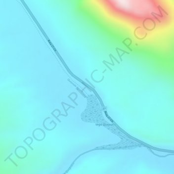
Name: Quepiaco topographic map, elevation, terrain.
Average elevation: 4,647 m
Minimum elevation: 4,570 m
Maximum elevation: 5,044 m
Thank you for supporting this site ❤️
Make a donation
Make a donation
Gear up for your next adventure:
As an Amazon Associate, this site earns from qualifying purchases at no extra cost to you.
Other topographic maps
Click on a map to view its topography, its elevation and its terrain.
Laguna Chaxa
Chile > Región de Antofagasta > Provincia de El Loa > San Pedro de Atacama
Average elevation: 2,303 m
Laguna Tebenquiche
Chile > Región de Antofagasta > Provincia de El Loa > San Pedro de Atacama
Average elevation: 2,315 m